
 WWSB
WWSB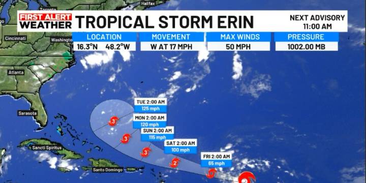
SARASOTA, Fla. ( WWSB ) - Satellite images show Erin still producing strong thunderstorms, with its center just northeast of the thickest clouds. Not much has changed since the last update, but recent data suggests the storm’s cloud bands are becoming a little more organized. Wind speeds are holding steady at about 52 miles per hour (45 knots).
Erin is currently in an environment that should allow it to slowly get stronger over the next day or so. After that, it’s expected to move over warmer waters and encounter lighter upper-level winds, which could help it strengthen more quickly between 24 and 48 hours from now. Conditions remain favorable, and there’s a good chance Erin could become a major hurricane (Category 3 or higher) by around day 3. Some models even predict it could get stro

 FOX 13 Tampa Bay Crime
 Florida Today
 Wilmington Star-News
 Sarasota Herald-Tribune
 Tampa Bay Times Health
 Florida Politics
 Law & Crime
 Ocala Star-Banner