
 WYFF News 4
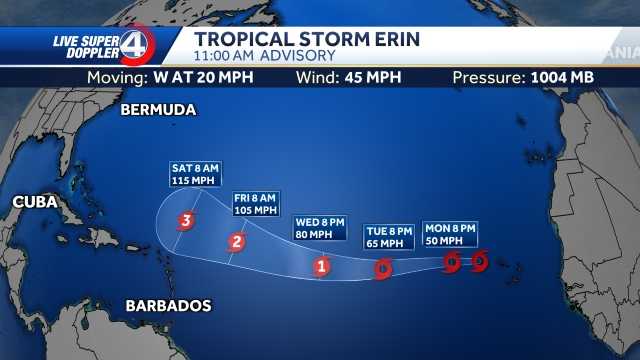
GREENVILLE, S.C. —
Erin has become a Category 4 hurricane in the Caribbean, with expectations to strengthen further on Saturday, according to the National Hurricane Center.
Hurricane Stats For now, most forecast models keep Erin over open waters through the week, with many models still showing a classic northward “recurve” between Bermuda and the Outer Banks.
Spaghetti Models
Erin could form huge waves off of the East coast through the weekend and next week. With the storm's size, waves could reach 75 feet. There will also be a risk for rip currents off the coast through next week.
Hurricane Track
We will continue to monitor each new update and bring you the latest track, timing, and potential impacts as the week unfolds.

 FOX News Videos
 WSPA 7News
 The Free Press - TFP
 The Greenville News
 FOX Carolina
 WIS News 10 South Carolina
 WBTW Grand Strand
 WRDW-TV News 12 Crime
 SCNOW
SCNOW Raw Story