
 WTKR
WTKR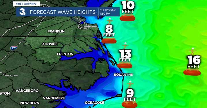
Derrah Getter's First Warning Forecast
This evening will be pleasant and warm. Spotty showers pop up overnight but dry conditions return by daybreak. Temperatures out the door Monday morning will be in the low to mid 70s.
Monday afternoon will be mild with highs in the mid 80s. A few more isolated storms will be possible in the afternoon.
Hurricane Erin's path off the Atlantic coast will lead to dangerous beach conditions especially Wednesday and Thursday. There will be a high rip current risk all week long. Maximum wave heights between 10 and 12 feet are forecast.
Tropical storm force winds and heavy rain will be possible for portions of the Outer Banks and coastal flooding will likely make some roads impassible.
Let's connect on social media!
Forecaster Derrah Getter:
For weather

 KRWG Public Media
 Corpus Christi Caller-Times
 KETV Omaha
 Eyewitness News 3
 WKOW 27
 Wilmington Star-News
 Courier Post
 Ocala Star-Banner
 KSNB Local4 Central Nebraska
 WBAL-TV 11 Baltimore Covid-19