
 Action News Now
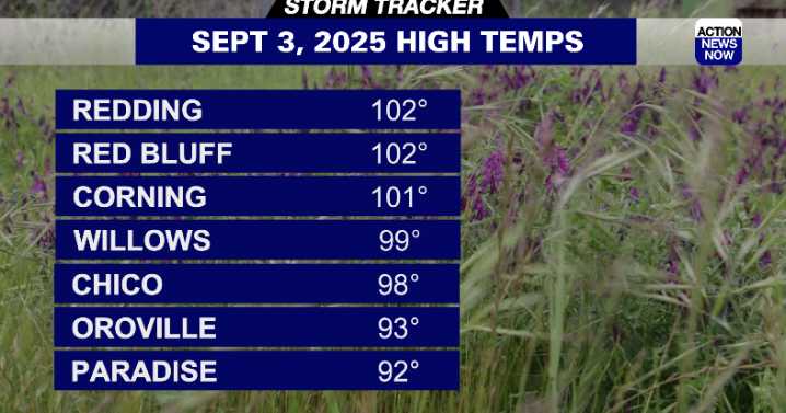
WHAT WE’RE TRACKING:
Storms off of the California coast are moving from south to north. They will bring periodic breezy winds as well as push some moisture up into the area which could lead to mountain thunderstorms (10-25 percent chance) through Thursday (better chances Thursday). These storms will continue to drop temperatures through Friday.
PLANNING YOUR NEXT 24 HOURS:
Sunny and hot (S 5 MPH but calm early)
EXTENDED FORECAST:
Temperatures will cool even further through the weekend. Winds will be breezier (SE 15 mph) as storms move close and bring moisture to the area from the ocean. Temperatures will remain below average for most of the forecast period.
ACTION NEWS NOW STORM TRACKER FORECAST:
TONIGHT:
Mostly clear and mild
Low: 70
Wind: S 5 MPH becoming calm in the evening

 The Weather Channel
 KTVB 7
 KSNB Local4 Central Nebraska
 Joplin Globe
 WBKO
WBKO New York Post
 The Bay City Times
 FOX Weather
 NewsTalk 1280