
 Eyewitness News 3
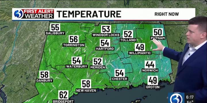
For any Alerts in effect for CT, click: here .
TONIGHT...
Any isolated showers this evening end. Cloud cover erodes overnight, with patchy fog developing by daybreak, especially in the river valley areas or where rain was received. Temperatures bottom out in the 50s inland, lower 60s at the shoreline.
SUNDAY...
In advance of a weak front heading our way, an isolated shower is possible during the afternoon (most communities remain dry). Otherwise, expect a mostly sunny sky with highs near or just above 80 (up a couple degrees, compared to today).
NEXT WEEK...
High pressure will build back into the region for much of the upcoming week bringing with it lots of sunshine and warm temperatures. Around Wednesday, we’ll be monitoring a disturbance to our south that could spread scattered c

 KSNB Local4 Central Nebraska
 ABC News Weather
 KOMU 8
 Arizona Republic
 AlterNet
 Mediaite
 CNN Politics
 ABC30 Fresno Sports
 The Daily Beast