
 WRCB-TV
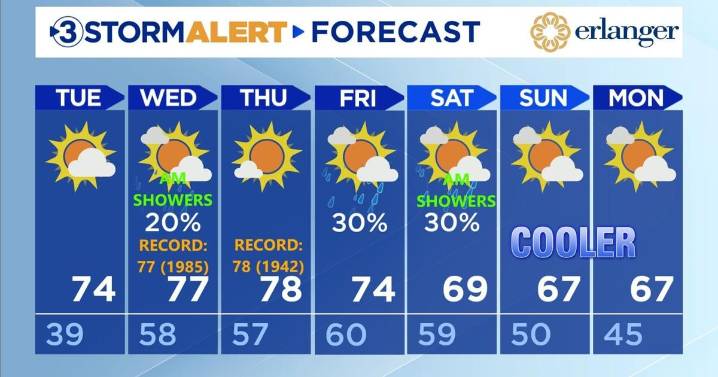
Good Monday. Tonight we will have a few clouds with chilly temps overnight dropping into the mid to upper 30s by morning. We will warm quite a bit to a high of 74.
Wednesday and Thursday, we will have possible record highs. Wednesday we will hit 77, which would tie the current record set in 1985. Look for a few showers possible Wednesday morning. We will tie the record again Thursday with a high of 78, set previously in 1942. Skies Thursday will be mostly sunny.
We may have a few on-and-offOn showers through the day Friday into Saturday morning. Friday will have a high of 74.
Cooler weather will settle in for the weekend with highs returning to the mid to upper 60s Saturday and Sunday.
For the latest, download the Local 3 Weather app.

 KNOE
KNOE Alabama News Network
 Sweetwater Now
 WSIL-TV
 WHAS 11
 CNN Climate
 New York Post
 WMAR-2 News
 Arizona's Family
 Times Herald-Record
 WREX
WREX PennLive Pa. Politics
 Law & Crime