
Tonight: Temperatures in northeast Iowa warm into the low 30s with areas farther south in the mid to upper 30s. Temperatures remain that way until about 2 or 3 AM with a light wintry mix. There could be some patchy freezing drizzle to put a glaze of ice on surfaces north of Highway 20. Temperatures drop into the 20s by sunrise area wide. The wintry mix this evening changes to light snow after midnight. Any snow accumulation is less than 1”. The wind increases this evening. From 10PM to 10AM Wed, wind gusts are 40+ mph from the west and northwest. Inside of that range, between 1AM and 6AM wind gusts are near 50 mph. This will cause blowing and drifting snow from the snow already on the ground, especially in open areas. Roads are expected to be slick, so use caution. Visibility can be redu
TRACKING: Near whiteout conditions tonight and Wednesday morning
 KWWL4 hrs ago
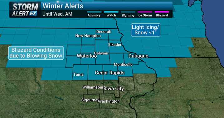
146

 Bring Me The News
 KSNB Local4 Central Nebraska
 West Kentucky Star
 WCNC Charlotte
 CBS Philly
 WWSB
WWSB KOMU 8
 KOLO8
KOLO8 WNNY-TV
 Esquire