
 USA TODAY National
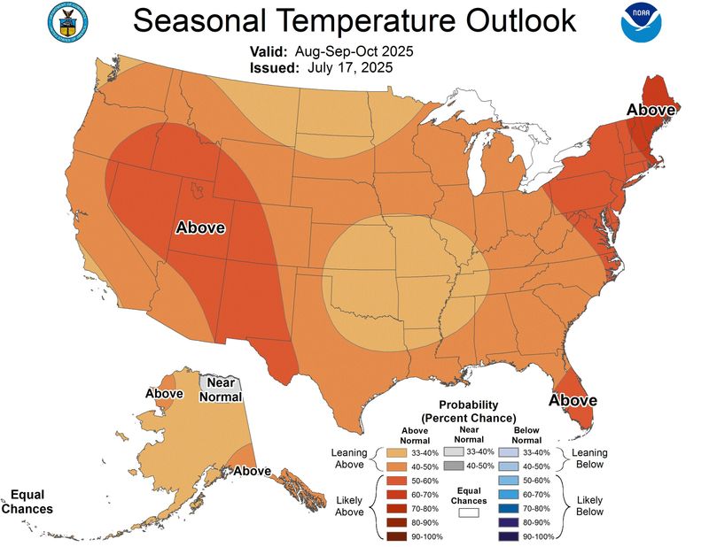
Weather forecasters have their first predictions about what to expect as hot summer weather turns to a cooler fall — or doesn't.
Forecasts of above-average temperatures abound, along with concern about what a hot fall could mean for wildfires.
A July forecast from the Climate Prediction Center was an early warning for fall, as forecasters saw signs of "above-normal temperatures for almost the entire country," through October.
AccuWeather predicts that warm, humid air will hold firm across the eastern United States through the start of autumn, delaying the true arrival of fall-like weather conditions.
And in the West, wind events may spark large fires in central and southern California as early as September, while lightning from moisture-starved thunderstorms could ignite fires farther north, according to AccuWeather meteorologist Brian Lada.
Meanwhile, wildfires roaring across Canada and the western U.S. will continue to bring rounds of smoke into the sky over parts of the Midwest and Northeast this fall, forecasters warned.
“Millions of people from Minneapolis to Chicago will likely see more rounds of wildfire smoke and a hazy sky into the middle of the fall season," AccuWeather meteorologist Paul Pastelok said. "The wind and weather patterns will continue to carry wildfire smoke high in the atmosphere from the western U.S. and Canada over parts of the Midwest and Great Lakes, into the Northeast.”
While summer's scorching heat shattered records in some areas, it also brought widespread, historic and deadly flooding in several states, including Texas, New Mexico, New York, and North Carolina.
Tropical storms and hurricanes will fuel the flood threat throughout the late summer and autumn, with the most flood-prone regions expected to be the Appalachians, the Ohio Valley and the central Gulf Coast, AccuWeather said.
Historic heat in summer 2025
Summer 2025 has already been a scorcher, with much of the eastern half of the nation enduring weeks of high heat and tropical humidity, with more expected in the coming weeks. For example, the state of West Virginia endured its hottest July ever recorded, according to the Northeast Regional Climate Center.
And Philadelphia, Pennsylvania, also tied its all-time record for greatest number of days with a high of at least 90 degrees, seeing 21 such days in July, the climate center said.
Other notable marks included heat indeces that soared to 120 degrees in Florida and 128 degrees in Missouri.
Fall forecast brings renewed wildfire worries
The wildfire threat will be elevated across the West through the first half of autumn, particularly in California, the Rockies and Northwest, forecasters said.
Wildfires have already made headlines this year, thanks to the horrific fires in the Los Angeles area in January, which scorched tens of thousands of acres and left dozens, perhaps hundreds dead.
More recently, large wildfires have already been underway in early August in the West: As of Aug. 7, the largest uncontained or partially contained fires are the Dragon Bravo Fire burning in the Grand Canyon National Park in Arizona and the Gifford Fire in Southern California, according to InciWeb.
In addition to the threat for fires in the West, the Great Lakes region may also face fire concerns during dry, windy periods, Lada said. "If dry stretches persist, parts of the Northeast and Carolinas could see heightened fire risk this fall," he said.
As well, "dry fuels from Hurricane Helene in 2024 continue to be a high risk in western North Carolina, northwestern South Carolina and northern Georgia," Pastelok said.
42,000 fires so far
As of Aug. 7, there have been over 42,000 wildfires in the U.S. this year, which is the most as of this date in at least the past 10 years, according to the National Interagency Fire Center (NIFC).
So what's going on? "You're correct that the number of wildfires reported so far in 2025 is tracking higher than what we've seen in recent years," NIFC spokesperson Rebecca Paterson told USA TODAY recently. "However, when quantifying fire activity, it's also helpful to look at not just the number of fires, but how many acres those fires have burned.
"So far in 2025, the total number of acres burned is below the 10-year average," she told USA TODAY.
That "could suggest that many of this year’s fires have remained smaller, or have been more quickly contained," Paterson said, although researchers can't say for sure.
But the wildfire picture could rapidly change as summer turns to fall, Paterson said: "...it is still relatively early from a fire activity perspective. August is typically the month that sees the most activity on average nationwide."
Summer brought historic flooding too
From Texas to North Carolina, Illinois to New Mexico, deadly floods have surged into the national spotlight this summer, AccuWeather reports. A slow-moving storm in central Texas dumped over 12 inches of rain in Kerr County, causing the Guadalupe River to rise 27 feet in under an hour, killing more than 130 people.
In addition to the Texas floods, Tropical Storm Chantal shattered a rainfall record in North Carolina’s Eno River basin and claimed six lives. In Chicago, flash floods overwhelmed streets in under two hours. In New Mexico, floodwaters tore through fire-scarred terrain in Ruidoso, killing at least three people.
"So far in 2025 across the U.S., there's been a 70% increase in reports of flash flooding when you compare that to the 10-year historic average through mid-July," said AccuWeather chief meteorologist Jon Porter in an online report. "This means that there have been more than 4,800 reports of flash flooding. That's a huge number and why so many people feel like they've been hearing a lot about flash flooding in the news."
Why so rainy? So far this summer, the overall weather pattern has helped fuel extreme rainfall, in part due to a stronger-than-usual Bermuda High – a persistent area of high pressure near Bermuda that often influences summer conditions across the U.S., AccuWeather said.
In addition to the strong Bermuda High, a very active storm track from Canada has allowed ample opportunity for thunderstorms not just in the Ohio Valley and Midwest but farther south and in the Northeast.
This article originally appeared on USA TODAY: First glimpses of fall 2025 forecast warn of high temperatures across USA
Reporting by Doyle Rice, USA TODAY / USA TODAY
USA TODAY Network via Reuters Connect

 The Post and Courier
 New Jersey Herald
 NECN Providence
 WITN-TV
 Kitsap Sun
 Santa Maria Times Local
 Arizona's Family
 KOLO8
KOLO8 WAFB
WAFB OK Magazine