
 ABC11 WTVD
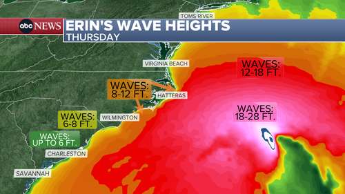
RALEIGH, N.C. (WTVD) -- ABC11 First Alert Weather team is continuing to track Erin , which strengthened into a hurricane Friday, and its impact on North Carolina.
Erin is expected to stay offshore but will make its closest approach to the NC coast around Wednesday or Thursday. As of right now, impacts are limited.
This weekend
Beach plans? The weather looks great for the NC coast, with highs in the 80s and a low to moderate rip current threat.
Sunday and Monday
Long-period swells from Erin will begin impacting the southern NC coast. This could lead to hazardous boating conditions in shallow waters, such as Frying Pan Shoals, Winyah Bay, the Cape Fear River, and nearby inlets.
Next week
Marine and coastal hazards are likely, including increased rip currents, potential coastal floo

 WBTV Mecklenburg County
 WITN-TV
 Greensboro News and Record
 WCNC Charlotte Weather
 The Morganton News Herald
 Wilmington Star-News
 Florida Today
 Orlando Sentinel Politics