
 KFVS12
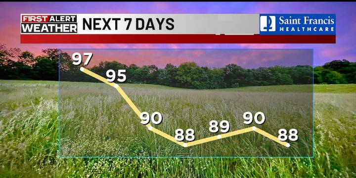
(KFVS) - Extreme heat continues over the next couple of days, but relief is on the way.
Today will likely come close to being the hottest day of summer.
Afternoon highs will range from 95 to 100 degrees with heat index numbers of about 105 to 110 degrees.
Extreme heat warnings, watches and advisories are in effect through Tuesday evening.
Tuesday will start off hot and humid, but there will be more clouds and some isolated, but potentially strong, thunderstorms by afternoon and evening.
Highs on Tuesday look to range from the low 90s north to the upper 90s south.
Occasional showers and thunderstorm chances could linger on Wednesday and Thursday.
The rest of the week should be more comfortable.
Afternoon highs on Wednesday through the weekend look to be about 85 to 90 degrees, with

 Eyewitness News 3
 WKOW 27
 Wilmington Star-News
 KSNB Local4 Central Nebraska
 The Week
 Alabama News Network
 FOX 10 Phoenix Latest
 FOX 32 Chicago
 WBRC
WBRC Political Wire