
 21Alive News
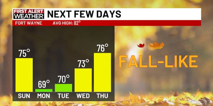
FORT WAYNE, Ind. (21Alive) - Afternoon temps will max out in the low-to-mid 70s for the days ahead!
Don’t forget to bring a light jacket because it is a crisp fall-like morning. Temps will mostly stay in the upper 50s and low 60s. Some areas of patchy fog are also possible, but don’t expect it to be too thick and cause many issues!
Later today, it won’t get too much warmer with below average temps expected and afternoon highs in the mid 70s! It will stay partly sunny and dry today, so any plans to head out look to fair alright!
YOUR NEXT FIRST ALERT:
More chilly days are ahead of us this weekend!
Expect partly sunny skies for Monday and Tuesday with highs in the upper 60s and low 70s. A stray lake effect rain shower is possible both days, but it shouldn’t be anything to cancel your pl

 WBRC
WBRC 93 WIBC Indianapolis
 The Times of Northwest Indiana Crime
 WTHR
WTHR Raw Story
 Mediaite
 The Christian Post
 She Knows
 Newsweek Top
 RadarOnline