
 FOX 13 Tampa Bay Crime
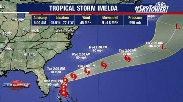
TAMPA, Fla. - FOX 13 Meteorologist Dave Osterberg is keeping a close eye on Imelda, which became a tropical storm on Sunday.
As of 5 a.m. on Monday, Imelda was located at 25.5°N 77.1°W.
It was moving north at eight miles an hour and had maximum sustained winds of 45 miles per hour.
The National Hurricane Center expects Imelda to become a hurricane on Tuesday.
How will Imelda impact Florida?
Why you should care:
Osterberg says Imelda will run parallel to Florida during the day on Monday, creating a dreary day, high surf and rip currents on the East Coast.
One or two showers will pinwheel around and impact the Bay Area on Monday, but overall rain chances will be about 20 – 30 percent on Monday and Tuesday.
On Friday, Imelda looked like it was going to hit the Carolinas, but no

 The Advocate
 Florida Today
 Sarasota Herald-Tribune
 Law & Crime
 FOX 35 Orlando
 NBC 6 South Florida
 WWSB
WWSB The Columbian
 Ocala Star-Banner
 Washtington City Paper