
 USA TODAY National
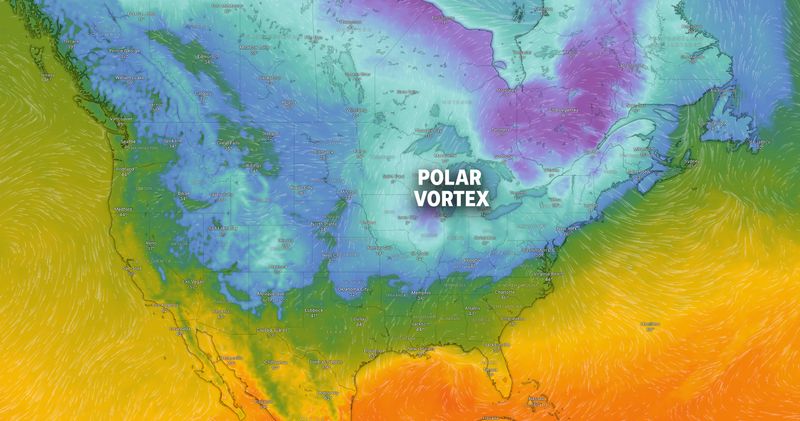
Frigid temperatures are expected to impact much of the central and eastern United States in the coming weeks.
The first of three polar vortex systems is expected this month, according to AccuWeather. The surges of Arctic air will generate rounds of flurries and squalls in certain locations and may assist igniting storms with more widespread snow.
"The outbreak this week will be the first of probably three such rounds with it. Another cold blast is likely next week and a third the week after that," AccuWeather Lead Long-Range Meteorologist Paul Pastelok said on their website. "The waves of Arctic air will lead to significant surges in energy demands."
December to have extremely cold temperatures
The Upper Midwest and Northern Plains have been hit by Canada's freezing temperatures. On Thursday, Dec. 4, wind chills between negative 10 to negative 25 degrees will be expected, and the cold temperatures are expected to continue into Friday, Dec. 5 for those in the eastern U.S.
According to AccuWeather, as the leading edge of the Arctic air moves southward, areas of flurries, snow and larger snow squalls might accompany the front as it sweeps across the Great Lakes region and into the northern half of the Appalachians.
Unable to view our graphics? Click here to see them.
How does a polar vortex form?
The North Pole is covered by the polar vortex, a massive circular upper-air weather system in the Arctic. It's a normal pattern that tends to contain the coldest weather close to the North Pole and is stronger in the winter. A portion of the polar vortex may occasionally break off or drift south, bringing freezing weather to the U.S., Europe and Asia. Normally, the jet stream locks the vortex in and keeps it there.
Winter's chilly winds can make it feel much colder
As temperatures begin to dip, cold weather significantly increases the risk of frostbite, especially as temperatures drop toward or below freezing.
The National Weather Service uses computer modeling to "provide an accurate, understandable, and useful formula" to calculate wind chill. According to the NWS, the index calculates wind speed at five feet off the ground – the average height of an adult human face – while incorporating "heat transfer theory based on heat loss from the body to its surroundings."
The wind chill index is a guide to help us understand how dangerous low temperatures and strong winds can cause frostbite. To determine the wind chill temperature on the chart below, locate the relevant wind speed at the top and the outside temperature on the right; you will find wind-chill temperature where they meet:
Contributing: Doyle Rice/USA TODAY, Cailey Gleezon, Milwaukee Journal Sentinel
SOURCE AccuWeather, National Weather Service and USA TODAY research
This article originally appeared on USA TODAY: A triple-dip Polar vortex is coming. Will your state feel the chill?
Reporting by Janet Loehrke, USA TODAY / USA TODAY
USA TODAY Network via Reuters Connect

 The Coloradoan
 The Gleaner
 Associated Press US and World News Video
 WAVE 3 News
 Courier Journal
 WYMT
WYMT AlterNet
 NFL Atlanta Falcons
 TMZ Video
 Associated Press US News
 America News