
 KSNB Local4 Central Nebraska
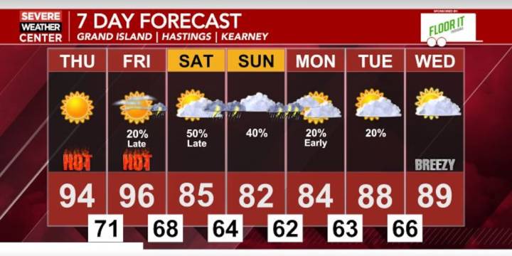
HASTINGS, Neb. (KSNB) - Temperatures are continuing to warm up throughout the week as today we had widespread 80’s to 90’s. Dew points in the upper 60’s and low 70’s added some mugginess to the air, but we’ll see higher dew points to finish off the work week. Starting with tonight temperatures fall back into the mid 60’s to the west with upper 60’s in central Nebraska and low 70’s to the southeast. Skies will be mostly clear tonight with a slight chance of thunderstorms across extreme eastern Nebraska into tomorrow morning. Widespread 90’s return tomorrow with a few spots reaching 100 in southwestern Nebraska. Dew points for the eastern half of Nebraska are expected to be in the low 70’s providing heat indices near 100. A Heat Advisory is in effect for tomorrow for western and northern por
Hot and humid finish to the work week before thunderstorm chances return this weekend
144

 1011 Now Crime
 WOWT Crime
 KOLN-TV
 KETV Omaha
 KETV NewsWatch 7
 The Washington Post Opinions