
 USA TODAY National
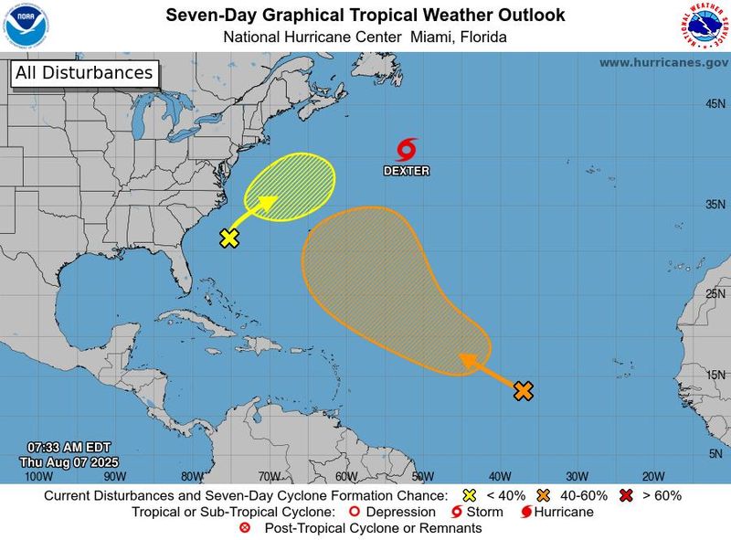
Editor's note: Click here for the latest on Dexter and tropical storms Henriette and Ivo for Friday, Aug. 8.
Tropical Storm Dexter is expected to strengthen in the north Atlantic Ocean while tropical storms Henriette and Ivo spin in the Pacific.
The National Hurricane Center said in an advisory on Thursday morning, Aug. 7, Dexter was located about 425 miles south of Cape Race, Newfoundland, with maximum sustained winds near 50 mph with higher gusts.
Hurricane center forecasters said Dexter is forecast to strengthen as an extratropical low later Thursday through Friday, Aug. 8, then will begin weakening Friday night into Saturday. The storm is expected to continue moving in a northeast direction for the next few days, and there are no threats to land stemming from the storm.
Elsewhere in the Atlantic, a weak area of low pressure located a few hundred miles off the southeastern U.S. coast is producing "minimal shower and thunderstorm activity." The hurricane center says some slow tropical or subtropical development is possible over the weekend and early next week while the system moves northward to northwestward, remaining well off the east coast of the U.S.
The NHC gives the system a 30% chance of formation through the next seven days.
Additionally, a tropical wave over the eastern tropical Atlantic is producing a large area of disorganized showers and thunderstorms, and environmental conditions are forecast to be generally conducive for gradual development.
A tropical depression could form over the weekend as the system moves west-northwestward across the central tropical and subtropical Atlantic, with the hurricane center giving it a 60% chance of formation through the next seven days.
Atlantic Ocean storm tracker
Tropical Storm Dexter spaghetti models
This forecast track shows the most likely path of the center of the storm. It does not illustrate the full width of the storm or its impacts, and the center of the storm is likely to travel outside the cone up to 33% of the time.
Tropical Storms Henriette, Ivo in the Pacific
Meanwhile in the Pacific, Tropical Storm Ivo is spinning about 215 miles west-southwest of Acapulco, Mexico, with maximum sustained winds near 40 mph with higher gusts.
Ivo is forecast to move parallel to, but offshore of, the coast of Mexico through the next day or two before turning westward away from Mexico thereafter. The storm is expected to strengthen into a hurricane by the end of the week, according to NHC forecasters.
The hurricane center said interests along the coast of southwestern Mexico should monitor the progress of Ivo, as the storm is expected to produce storm total rainfall of 2 to 4 inches, with isolated maximum totals of 6 inches, across portions of the Mexican states of Guerrero, Michoacan de Ocampo, and Colima through Friday. Swells generated by Ivo are also likely to cause life-threatening surf and rip current conditions for the next few days.
Henriette, meanwhile, continues to spin about 1,385 miles east of Hilo, Hawaii with maximum sustained winds near 45 mph with higher gusts. The storm is expected to continue moving west through Thursday before taking a turn toward the northwest on Friday and over the weekend, keeping the center of the storm well to the north of the Hawaiian Islands.
Little change in strength is forecast during the next few days and there are currently no threats to land stemming from Henriette.
Pacific Ocean storm tracker
How do hurricanes form?
Hurricanes are born in the tropics, above warm water. Clusters of thunderstorms can develop over the ocean when water temperatures exceed 80 degrees Fahrenheit. If conditions are right, the clusters swirl into a storm known as a tropical wave or tropical depression.
A tropical depression becomes a named tropical storm once its sustained wind speeds reach 39 miles per hour. When its winds reach 74 mph, the storm officially becomes a hurricane.
Prepare now for hurricanes
Delaying potentially life-saving preparations could mean waiting until it’s too late. "Get your disaster supplies while the shelves are still stocked, and get that insurance checkup early, as flood insurance requires a 30-day waiting period," NOAA recommends.
- Develop an evacuation plan: If you are at risk from hurricanes, you need an evacuation plan. Now is the time to begin planning where you would go and how you would get there.
- Assemble disaster supplies: Whether you’re evacuating or sheltering-in-place, you’re going to need supplies not just to get through the storm but for the potentially lengthy aftermath, NOAA said.
- Get an insurance checkup and document your possessions: Contact your insurance company or agent now and ask for an insurance check-up to make sure you have enough insurance to repair or even replace your home and/or belongings. Remember, home and renters insurance doesn’t cover flooding, so you’ll need a separate policy for it. Flood insurance is available through your company, agent, or the National Flood Insurance Program. Act now, as flood insurance requires a 30-day waiting period.
- Create a family communication plan: NOAA said to take the time now to write down your hurricane plan, and share it with your family. Determine family meeting places, and make sure to include an out-of-town location in case of evacuation.
- Strengthen your home: Now is the time to improve your home’s ability to withstand hurricane impacts. Trim trees; install storm shutters, accordion shutters, and/or impact glass; seal outside wall openings.
Gabe Hauari is a national trending news reporter at USA TODAY. You can follow him on X @GabeHauari or email him at Gdhauari@gannett.com.
This article originally appeared on USA TODAY: Tropical Storm Dexter to strengthen in north Atlantic: See tracker
Reporting by Gabe Hauari, USA TODAY / USA TODAY
USA TODAY Network via Reuters Connect

 The Post and Courier
 Kitsap Sun
 WITN-TV
 Arizona's Family
 KOLO8
KOLO8 WAFB
WAFB The Shaw Local News Sports
 ABC News Video
 WUSA 9 News
 New York Post