
 21Alive News
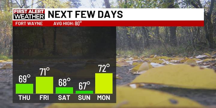
FORT WAYNE, Ind. (WPTA) - As the overnight rain moves out, a cooler trend settles in. Temperatures for the end of the week will be more on par with what we typically see for the start of October.
Cloudy skies kick us off on Thursday morning, but cloud cover will gradually move out as the day goes on. I expect us to see more sunshine by the end of the day. Highs will only reach the upper 60s across the region thanks to our latest cold front.
We’ll stay dry and very fall-like for all of the weekend events going on in 21Country. Expect high temperatures to range in the upper 60s and low 70s. The only weather nuisance we’re tracking is the windy conditions on Friday. Wind gusts tomorrow could reach up to 30 mph.
Today : Decreasing clouds; High 69; Wind NW 5-10
Tonight : Mainly clear; Low

 93 WIBC Indianapolis
 Foreign Policy
 IndyStar
 The Journal Gazette
 NewsTalk 1280
 The Times of Northwest Indiana Crime
 The Times of Northwest Indiana Local